With the aid of Google maps & too much spare time to think, I set about making a route and planning it so we’d stay inside the borders all the way round. To quote Hale & Pace’s Captain Boycott, “if it’s not in Yorkshire it’s not worth bloody seeing!”
Maps were printed, the route traced on, and mileages/fuel stops planned…it was going to be nigh on 500 miles all told, including getting to/from the start/finish from home.
Yesterday was the big day….me, Twist & Go Ray (on his GP) and Scooterstu were on the guest list.
The meet up near Thorne in Doncaster for the 6am start…

An uneventful run up to Goole, and round to Spurn Point threw up an unexpected spanner…the plan within the plan was to take photos at all 4 furthest out points of the compass that can be reached in Yorkshire by road…the easterly most point is Spurn….but the North Sea had seen us coming and crashed in, washing away part of the peninsula, cutting off the community living at the end by dumping tons of sand all along the concrete block road. The gate at the entrance to the nature reserve was chained, but we slipped past and made a valiant attempt at getting down there – but soon realised why only 4x4’s could do it!
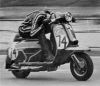
The break in the middle, that is the easternmost point, is seen between Ray & Stripey George.

Turning the bikes round was difficult…the best method of moving them without sinking in was to run alongside, while letting it go in first gear!

My fave shot from the day...Scooterstu in the background wondering what he'd got himself into

Bit late for the high tide warnings!

Sadly Stu’s ride was at an end by the time we reached Bridlington – rough running curtailed his part in the she-bang, and he limped back home the 80 miles or so to Wakefield in mostly 3rd gear.

Ray & I pressed on deflated….reaching Flamborough lighthouse for a break.

We reached Staithes, the northernmost outpost of Yorkshire in the afternoon, after a ride up the coast through Scarborough & Whitby.

Turning inland we cut through the top of the North York Moors national park….this bus shelter near Commondale was recently nominated as one of Britain’s most remote.

Sticking as close to the boundaries as possible we knew there’d be the odd brush with outside types….the brakes got a good workout here, before turning round!

We did transgress once though, crossing the Tees unwittingly after missing a turn up the last lane in Yorkshire…we quickly employed the “5 second rule” though, and decided if we got back into God’s own county quickly enough we wouldn’t be infected at all with any of that foreignness.
Back into the hilly, remote stuff, and once under the A66 we were in MOD firing range country…great roads though, and we had them all to ourselves…

Our route took us past Tan Hill, England’s highest pub…it’s reputation for remoteness well deserved

Leaving Tan Hill, early evening, & heading south it seemed we were the only people on the roads…it was a brilliant feeling

Reaching the renowned biker road over Butertubs Pass I had to stop with the camera…the Tour De France boys will attack it in a few weeks, and probably make it look simple – but it’s a beauty of a road…couldn’t stop for the better bits, as Ray was off in the distance!

A stop to juggle the fuel around near the Ribblehead viaduct – we’d been timed out and missed the last fuel stop in Hawes, so had to wing it over the moors to the reserve stop at Settle.


But first we’d to head out west & visit the westernmost tip by road, at Low Bentham, on the Lancs border…

Our route then took us up Cragg Vale towards Baitings Dam, scene of many scooter racing/hillclimb meetings. A sign at the foot of Cragg Vale read “Longest continual gradient in England”….and it felt like it was too – uphill all the way over 5.5 miles!
Time waits for no man, and it soon grew dark as we approached the M62 crossing – Scammonden Bridge – the highest motorway bridge in England.

Then disaster struck – a pitch-black tootle down a farm track led to me hitting a raised rock, scoring a direct hit on the u-pipe & turning Stripey George into a blaring foghorn of a machine….at midnight – in the middle of nowhere – and no real knowledge of how to get down off this ferkin’ hillside lane!
After pushing it along a few hundred yards over potholes, lake-type puddles & various other obstacles I decided to ride out, and then after 10 mins of riding up and down the next lane we found a way off the hill.
I rode the 25 miles back home, sure at any point I’d be pulled up, but I got back at 1.30am & stuck SG in the shed.
Checking this morning confirmed the damage

While a quick re-check on Google of the offending lane suggested it was probably a bit naïve, going down there in the first place!

Stripey George – is that mud from the lane, or did he stage a dirty protest overnight, at his treatment?

So, with only 80 miles left to do I felt crap at having got so close to the end…Ray would have doddled it, but chose to return home too, not really knowing the maps like I did…the roads I was most familiar with wouldn’t be visited, and I’d failed in my attempt.
The good thing is, there’s a will this morning to succeed eventually, so it’s one to be re-visited, and hopefully help to keep the pioneering scootery-type endurance event spirit alive.